Tuesday, May 21, 2013

Eastward Ho - From Idaho to MT.


Our day began early. I had the alarm set for 05:45 and Scooterchick asked me if I was ready to get up at 05:43......ok, ok baby I'm getting up. My darling has a habit of catching me in candid moments, like when I'm making coffee. I may have mentioned that we travel with a French Press to make coffee in our room. Let's face it, God doesn't want His people drinking bad coffee.......mmmmmmm.....coffee!!


Another candid shot. I'm still stumbling around rubbing the sleep out of my eyes and yawning, loading the luggage cart in preparation for the drive.


We head east from our hotel and drive past Lake Coeur D'Alene. The lake, region and city are named after an Indian Tribe that lived around the lake and it's tributaries. The name, loosely translated means "Heart of an Awl" because of their reputation as shrewd traders.


we detoured off the highway to investigate the tiny mining town of Wallace Idaho.


As we rolled into town there was an old Texaco station (always trust your car to the man that wears the star) replete with a GMC PD2903, vintage about 1949.


This is Bank Street drowsing in the early morning sun. It's about 07:00 by this time and we were actually looking for some breakfast.


Looking at one corner we can see a historic building that now houses an art gallery, sadly not open to browsers at this early hour.


On the opposite corner we see the Insurance Building, replete with turret. This was apparently a popular architechtural detail at the fin de siecle The 19th, not the 20th.


This building housed Pennaluna and Company which sold mining stocks. It is a sturdy brick job, with at least one apartment upstairs.

This alleyway reminds me of old Vancouver, minus the drug dealers and homeless listlessly wheeling their shopping carts in search of more recycleables.


Here is a view down the alley the other way. Note the absence of trash!


This building was the original railway station in Wallace. It has been resited here and upgraded to house the Northern Pacific Railway Museum. Though the rail line is gone, the grade remains and is advertised as the Route of the Hiawatha, a gentle ride via mountain bike from Lookout Pass downhill all the way to Wallace, a distance of 8-9 miles. With the plethora of trails and backroads in this area, Scooterchick and I though it would be an ideal spot for a moto-campground!!


We crossed over the aforementioned Lookout Pass and entered Montana. A few miles on we stopped at a Rest area, and I took this picture of the Montana road map.


Feeling as though turnabout was fair play, I lifted my phone to snap a candid pic of the chick who was looking at the poster affixed to the wall on the opposite side of the divider.


We continued to roll downhill into Butte. This is a picture in the parking lot of a mall, totally unremarkable except for the hills visible in the middle distance which are composed entirely of mine tailings. After the ore is extracted and processed the remaining spoil is dumped in long rows higher and higher until it forms hills several hundred feet high and several miles long. The same phenomenon is visible as you go down Whipsaw Hill towards Princeton B. C. and the reason is the same. Copper. The main company here is Anaconda, and during the Second World War, they were extracting a vein that was so rich (70%) that 3 shovels full of dirt equaled 2 shovels full of money!!


Due to errant placement and fatigue the next few photos are out of order....so sue me. These are mountains to the south of Lookout Pass. Ski season is over for this year, but Lookout got
 506 inches of fluffy Idaho Champagne Powder. Did I mention the pass rate is $229.00 for the 13-14 season. I could just barf! Need more info?  https://skilookout.com/


 Here is a view looking down the St. Regis river about 15 miles downhill from the pass.


This is looking upstream toward the west. The day is warm, the scenery exceptional.


Montana is known as Big Sky Country. Here is a glimpse of said sky with stratus and cumulus clouds for ornamentation.


By now it's about 09:00 and our stomachs are growling. Today's breakfast pales in comparison to yesterday's but we were able to check our emails with the complimentary wifi.


Again with the candid pics. Here am I schlubbing towards a breakfast burrito, hair akimbo in the morning breeze.


After breakfast we continue east, under that Big Sky towards Bozeman. The miles continue to mount up.


The road winds on, a long series of straight stretches broken by the gentlest of sinuous curves. All at speeds which would earn a $400+ speeding ticket in Canada, broken only by the occasional State Trooper passing us in pursuit of traffic travelling faster than us. Our cruise control was set at a leisurely 123km/h.


We stopped in Butte in search of snackies. We found these juicy morsels. The only drawback is trying to spit out the pits at over 70 m.p.h.


The other fruit on offer was Seedless Green Grapes, juicy and not too sweet. Delicious!


We continued on and crossed over the Continental Divide. From here all streams flow east to join the Mississippi River and thence to the Gulf of Mexico.


There were some interesting rock formations on the far side of the divide. We usually refer to these as Dinosaur Poo. The dinosaurs were busy here!


The road stretched on unwinding, we drove on unfazed, unblinking and undaunted!


As we continue on the Bridger Mountain range comes into view. These are named after the intrepid Jim Bridger explorer, mountain man, guide and raconteur. These are actually part of the Rocky Mountain Range.


We stopped at a Rest Area in Bozeman. Here am I with 3 flags, the Montana Flag, the Stars and Stripes and one commemorating POW-MIA service men.


There is a plaque honoring those who have served or are serving in defense of the nation.


Soon after Bozeman we approach Livingston. The mountain range in this view is the Gallatin Range. One would turn right here to travel down the Gallatin valley to enter Yellowstone National Park at the North Gate in Gardiner Montana.


This is a view down the Gallatin valley in passing. Although it is only 54 miles to the park entrance, it will have to wait for a another trip.


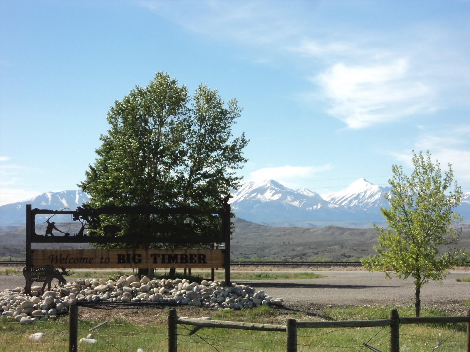
We stopped to get gas in the tiny town of Big Timber. Living on the Wet Coast we are acquainted with big timber and we saw nary a tree which would qualify here. Interestingly enough the mountains in the background are the Crazy Mtns. This is a contraction of the original Crazy Woman Mountains, referring to a Crow woman who went crazy after her family was killed during the westward expansion and lived out the remains of her life in this range.

At the end of a long day we found our lodgings for the night......HoJo. We stopped at Cracker Barrel for dinner, topped off the gas tank in preparation for tomorrow and settled in.


We have reached the end of the day together. I am sitting listening to Gospel music while I compose these remarks, which have reached their logical conclusion here. Good bye now.

Monday, May 20, 2013

Mish Mosh Motor

The time has come for another gripping yarn of intrigue, murder and espionage----wait did I think that out loud, I meant eating, packing and heading for parts previously unseen but known by virtue of (insert shameless plug here) Google Maps.

Since we have plundered the remaining food in the refrigerator, decimated the contents of the freezer and digested everything in the larder which can easily be boiled, baked or fried we decided to head out on Saturday for a bite.

When you live in Squampton, a town of 17,000 you have limited dining opportunities available, and those in the gourmet category are even more threadbare. We decided it was a nice enough evening for a short drive and thus found ourselves about 15 minutes south.


Does this look familiar? That's right it's the clubhouse at Furry Creek Golf Club. They have a lovely dining room, where we have idled away many a happy hour. The atmosphere  is "t'shrt and shorts" relaxed, the service relaxed and friendly and the food excellent.

As you can see the gardens are in good shape this year, effusive and understated at the same time. Well done them, I say.


The colors they use here are tasteful but not gaudy.


I have been in some truly nauseating restrooms in my time, you know the ones. You try not to touch anything, hold your breath as long as possible and exit quickly, hoping the scunge does not cling to you on the way out. That's why I have such a such admiration for a well executed bano. Furry Creek does not disappoint in this area.


The dining room is very open, high ceilinged and glass fronted. Since it was a little cool, we opted to sit inside today, where we usually dine al fresco. There was only one other couple there, and they left so we had the place to ourselves until another couple  foursomes came in off the course.


This evening we opted for a light repast, Pulled Pork Barbecue Poutine (you heard me-wipe that drool off your chin), Mango Salsa Crab Cakes and a House Special Club Sandwich with Applewood Smoked Bacon and Gruyere which came with a Toasted Garlic Tomato Bisque. We enjoyed our meal overlooking the 18th. hole and Howe Sound. Peaceful in the extreme.


After we finished our comidas, we waddled to the conference room which overlooks the creek for a picture. I spotted a better vantage point and determined to improve my guerrilla photo skills.


We went up hill a little and I did a little trekking through the bush, on a trail that looked fairly well worn to snap this pic. I should add that one step to the left would have me pitched into a 45 foot deep ravine, and one step forward would tumble me head over heels down 50 feet into the creek which was rollicking with spring meltwater.


We returned to our little shack in the bush and watched a movie, Analyze This with Robert De Niro and Billy Crystal. This one is always good for a laugh, but parents are strongly cautioned. The language is very foul in places.

We were about ready for bed by 10:30 and neither one of us was overly surprised when we were wide awake staring at each other by about 05:45 grinning like idiots, anxious to be on the road. We had preboiled some eggs, so we quickly pressed some java and I loaded the car and hitched up the trailer and we rolled out of Dodge by 7:00.


We had a quick stop in West Vancouver to check the mail, then out Hwy. 1 and over the new Port Mann Bridge. It's convenient to pay with a credit card using one's phone. Not overly taxing for a fella like me.


We stopped in Princeton for gas and chow. Again small town limitations on cuisine apply, so we made the best of a bad situation and went to A&W. Chubby Chicken and the Whistle Dog are off menu, as are the carhops so we did the best we could and had a burger and frosty mug of Root Beer.


Here am I looking less than enthused about the idea of a grilled burger.


The Root Beer helped, and they are still serving it in mugs fresh from the freezer so you get the frost on the outside of the mug. Cheap thrills I know, but fortunately some things never change. Still the same as it was in the 60's.


As we were preparing to leave the female bike invasion began. Most of these ladies were quite petite and they were all riding bikes that were at least 1100c.c or in some cases up to 1800c.c.

Good for them I opine! No more relegation to the pillion. Chicks can twist the throttle at least as well as dudes, in some cases better, as men can be foolhardy and women are careful riders.


There were maybe a dozen, mostly on V-Twins but a few on Gold Wings. Ride on ladies!!!


We rolled eastward to Keremeos, and took this picture for Trobaitiz, who spent some years there.


Up the hill and past Yellow Lake,  a popular fishing spot in both summer and winter.


Then downhill past Skaha Lake and into Penticton. We thought we should take the opportunity of visiting my Aged Mater, who will be 90 this year.


 Here is the lady in question, still chugging along although in low gear at present. Scooterchick had a pot of Butter Chicken which we brought up with us, Served up with Steamed Broccoli and Rice. Can you say yummy? I know you can.


One last kiss before we head out. See you later Ma! We headed out from Naramata this a.m. at 6:00


Here is my darling, cuddling up to the mom-in law. My mother loves Patsy, and can you blame her?


The sun was just coming up as we passed Okanagan Falls at the bottom end of Skaha Lake. I really like OK Falls. It has the right combination of location, sleepy good nature and historic value. Too bad the prices for everything in the area are in the "in the realm of the ludicrous".


 We continued on down Hwy. 97 and passed Vaseaux Lake.  This is a look South towards the bottom end of Vaseux. I understand there are bass in this lake, although I have not tested the premise.


This picture is looking north up the lake. You can see from the shadows that the sun is not quite up yet. This is because it isn't even 07:00 and here we are rocking it old school!


We made it to the border around 07:15, and cleared through with a minimum of fuss. Nexus helps as always. This time the CBP fellow must have been bored, because he asked to look in the trunk, before wishing us a good journey. We were the only ones there.


Welcome to the Evergreen State. We headed south and  started considering breakfast.


We slowed down to pass through a small town and Patsy spotted an antique store. Hold on Nelly!
We looked at the stuff they had on the sidewalk, and really wanted a wought iron tete a tete.


We looked at numerous other things and pondered the advisiblility of transporting such wonderful finds all the way to Oklahoma.


Here is the bench in question. We both agreed that it was a) adorable, b) affordable and c) would look great in the back yard, and retired to breakfast to think it over.


This is the sidewalk in front of the Old Creamery Antiques. There's a lot to be said about a town where one can leave wares their out overnight without them "taking a walk."


So, while we consider, I walked across the street to the Chamber of Commerce building to use the bathroom, which was open although the Chamber was closed. Of note to our fellow ADV'ers, there was a grassy yard behind the building with a sign saying "Bike Camp". Say no more!!! Did I mention the open bathroom with hot water and room to change your duds?

They have a display of plaques showing the forefathers with descriptions of their history and accomplishments in this area. Very informative.


We decided to try Shannon's Cafe, lured by the big deck and spreading Catawba Tree.


Here is a view back from the deck towards our parking spot on the other side of the road.


Here is Scooterchick's Breakfast, 2 Scrambled with Cheese, Sausage and Toast. And a cold glass of Apple Juice. Hmmmmmmmmmmmm.........looks good enough to eat!


I opted for 2 Scrambled, Bacon Crisp and French Toast. The  Eggs were good, the French Toast was really good, but the Bacon was outstanding! They get it from a local meat packer and those guys know their Bacon. Thick crunchy and meaty.


We decided that the furniture would likely disappear off our trailer "somewhere in the night" (thanks Barry) before we crossed the Oklahoma state line. Sad but true......

We continued south towards Omak (site of the suicide race)  https://www.youtube.com/watch?v=Stbmzv3afzM , took a left and headed up over the hill towards the east.


Once we came down the side we got our first glimpse of the Columbia, and the Grand Coulee Dam. Since my beloved has never seen this wonder, we stopped at the visitor center.


We passed through the small neat town of Coulee Dam. The speed limit through here is 25, the streets narrow, the houses well-kept and the yards groomed.


We cross over a small steel bridge that has a sign saying "give way to wide loads". Sh'yeah!


Now we approach the Visitor Center and Pat gets her first real look at the awesomeness that is the Grand Coulee Dam. Built as part of the WPA starting in 1939 it contains 12,000,000 cubic yards of concrete. You could build a sidewalk 4 feet wide and 4 inches thick twice around the earth at the equator with this much mix. The spillway is about 1660 feet wide and 550 feet high.


Here is your intrepid scribe soaking up a little sun and majestic view.


Here are the invincible travelers in a self portrait.


Here is another picture. a gentleman coming out of the Visitor Center offered to take this for us. Kind of him I thought. The object I'm clutching is a pair of shorts. It's getting warm and I need to shed some clothing. It's now about 09:30 and getting hot.


Here's a closer up view with the roaring water of the spillway behind us.It flows about 1,000,000 cubic feet per second at full flow.


Here is a plaque describing the salient facts of the structure. This is at the entrance to the Visitor Center. We enter to see what is what.


After watching a short movie about the dam itself, and another short movie about the geologic history of the Grand Coulee we look at the exhibits. Here my beloved models a diving suit that was assumably used in the construction of the dam.


Here is yours truly making out mark in the visitor record prior to our departure. a quick scribble and out to the car. The road awaits.


Here is a look back towards the Visitor Center. We were just about the only folks there.


We headed toward the east. Here is a picture of the puffy white clouds looking toward the north.


This is the very northern edge of the Palouse, an area of rolling hills and agriculture that stretches from here to Lewiston ID almost 200 miles to the south. This area is truly unique.
  http://photomoodblog.files.wordpress.com/2013/02/photo-mood-palouse-valley-landscape-photo-11.jpg   Yeah, that Palouse!!!


This is a picture of Rape. You probably know it as Canola. They changed the name in the 60's to make the oil more commercially palatable. The seeds of the mature plant are squeezed for their high oil content, and they decided Can, for Canada and Ola for oil would sell better .


We pass Fairchild AFB and the town of Airway Heights, and stop for a bite to eat in Spokane.


This is Spokane First Presbyterian. We didn't stop to take a closer look, just a picture from the highway in passing. Looks worth investigating though, perhaps another day.


Soon after we got back on I-90 we enter Idaho. It was a short hop to our stop for the night in Coeur D'Alene. We get settled in for the night and begin transcribing our travels.


The end of my post has come. Too soon? I'll have to address the continuation of this trip tomorrow. If you can spare the time, please pray for the survivors of the tornado in Moore Oklahoma, and for the grieving families that have lost loved ones and all their possessions earlier this afternoon. Thank you and good night.